 D
D
EHRENDORF
Landschaftsökologie und Umweltprojekte
D
D
EHRENDORF
Landschaftsökologie und Umweltprojekte
|
Process GeoROP:
|
|---|
|
(proszę wybrać język - bitte wählen Sie Ihre Sprache - please choose your language)
|
|
Workflow GeoROP: |
||
|
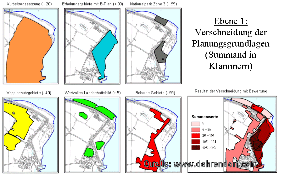
The company DEHRENDORF has developed a GIS- (Geographic Information System) based process to create and manage complex spatial planning maps by means of GIS. A first prototype – called GeoROP - was installed and evaluated in the county of Friesland in North-Western Germany (GIS-Software provided by LAND+SYSTEM, Bremen). The system GeoROP controls the planning-process starting from the stocktaking “basic and subject- specific data and information” (s. "level 1" in the illustration), the selection of zones with different social, economic and ecological requirements (level 2), the display of conflicts (level 3) and finally the management of conflicts in overlapping zones of land-use (level 4) by parameters predefined by the user. By setting of parameters - displayed in four DBMS tables - the user defines which aspect serves as basis of planning (such as conservation or recreation areas, water reserves, areas with certain priorities as agriculture, raw material) and how their relevance is evaluated. The user defines which zones of land-use can overlap and which create conflicts. In order to regulate the conflict management the user also defines a hierarchy of the zones of land-use represented in the plan. After the definition of the parameters the whole system can work automatically. So the consequences of any change of the basics of planning or the investigated alternatives can be shown at once in the result of the planning process. The main target of the project that started with the presentation at Eko-Konsult, Gdansk (s. a. News) is to develop the GeoROP prototype into a WebGIS-application suitable for the spatial planning requirements of all european countries and all users, who introduce spatial plans (i. e. regional masterplans, preparatory land-use plans, landscape plans etc.) in public and private planning agencies, universities and research institutes. An important part of the software development is the integration of an userfriendly interface to manage the participation of citizens and public authorities (E-participation). A comprehensive description is published in Dehrendorf/Heiss - Geo-Informationssysteme in der kommunalen Planungspraxis (s. publications) |
||
Input by the User: |
Automated sequence: |
Output (provisional results): |
| Basis of planning: | (conservation or recreation areas, water reserves, areas with certain priorities as agriculture, raw material etc.) | |
|
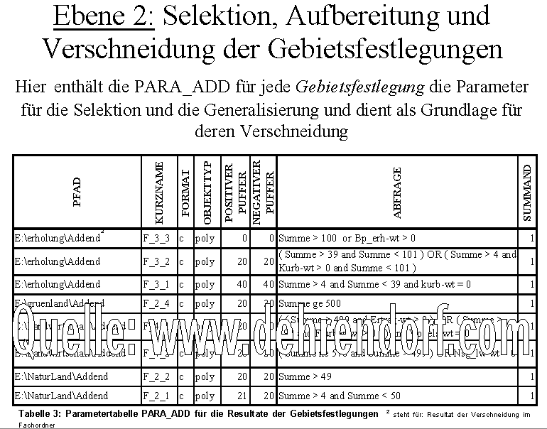
1rst table of parameters:
(List of basis of planning)
|
Level 1: converting, selection, evaluating and intersection of the basis of planning |
Result of intersection:
(suitability for an certain thematic field, i.e. recreation)
|
|
2nd table of parameters:
(List of areas)
|
Level 2: Selection and intersection of areas from provisional results of level 1 |
Result of intersection:
(Basis of the the presentationof conflicts) |
|
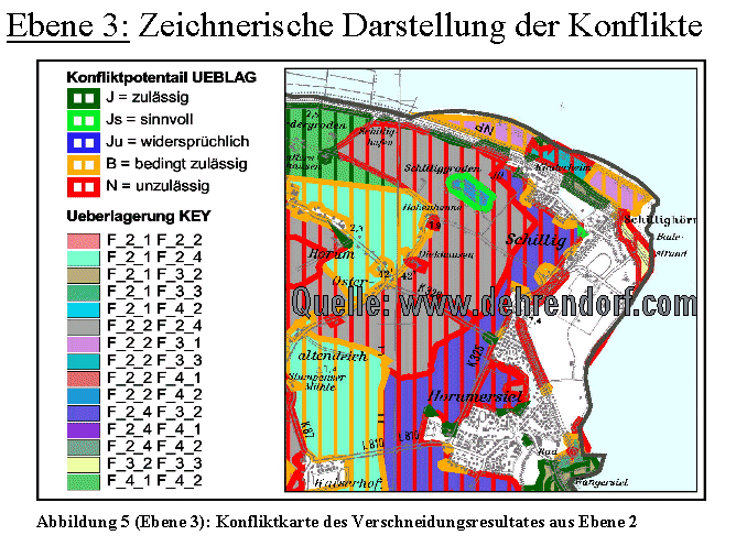
3rd table of parameters:
(assessment of conflicts)
|
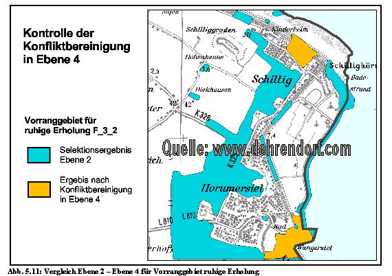
Level 3: Presentation of conflicts between overlapping areas |
Map of conflicts:
|
|
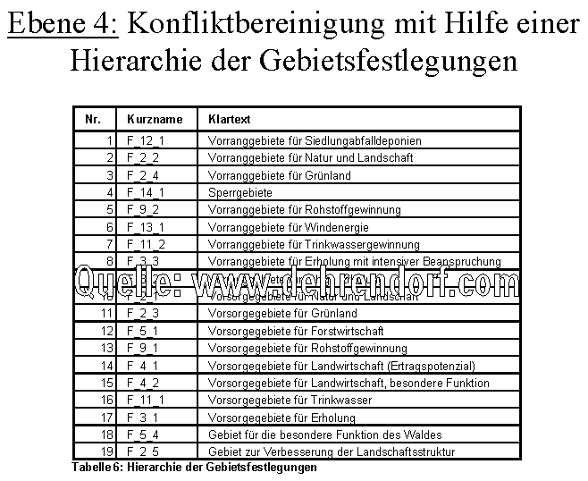
4rth table of parameters:
(Hierarcy of areas)
|
Level 4: selection of areas without conflicts |
Disentangling of conflicts:
(check of results)
|
|
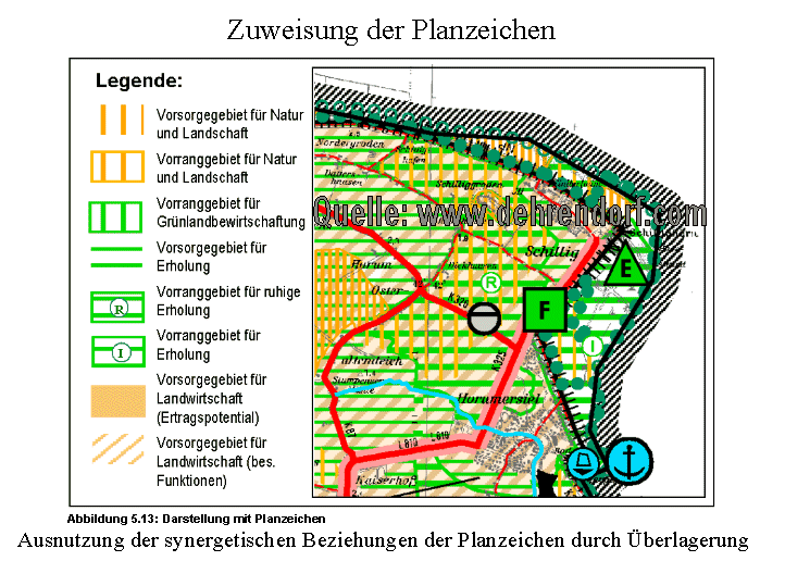
Presentation of result: (after drawing signatures have been assigned to the areas)
|
||


| News |
| contact |